*NEW*
okay... so i've gotten bored with the 'migrating posts from my old typepad blog' tedium... i'll try to get it done at some point, but i want to start posting about what i am working on right now... of course i don't think i can get into it any detail at the moment [ at least not with any images ] due to lack of sleep and subsequent lack of focus.
i will, however, give a brief description of the trajectory of my work. so here goes...
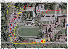
i finished out the year last spring working with gps mapping. i made a quick test using a holux gm-210 usb gps puck and a piece of open source software called kismac. this is a mac application developed, i believe, from a linux application called kismet; the program is designed primarily as a wifi stumbler, but it has a secondary feature used to map paths and mark wifi APs using data from an attached gps receiver. since i knew very little about gps mapping at that point i just used this to record my path as i walked and drove around campus. i was able to save the paths as vectors and tried to underlay a map of the area... it didn't line up very well [ probably my fault ] so i adjusted things in illustrator a bit... [ maybe i can find the direct import image and post it to flickr sometime ] so this really is kind of faked... here's a detail. there are a couple others on my flickr site [ just click the image ]
so, back to this year... we are working on a project that will travel the country later this year... it's unofficially [ and rather uninspired-ly ] called 'the trailer project' and is probably explained in more detail on some of the other students' blogs [ check out doug's for example ]. but quickly it's a 45 foot long, retired flatbed trailer that we will 'chop' and have towed to a number of schools and institutions across the country. my contribution to this will be an adaptation of an un-realized project i was working on last year [ the where's eric project ]. i will place a computer on the bed of the trailer, hook up an internet connection via a cel phone, connect a gps, add a number of cameras and track the thing along it's journey... auto posting this information to a website and recording in onboard.
whew... that's kind of intimidating me now... it seems like a lot of work, but i think i have my head around most of it... each component will have to be hacked or chopped to some degree in order to bend them to my will. i've succeeded on several accounts so far all of which i will dedicate some space to explaining at a later date. stay tuned...
i will, however, give a brief description of the trajectory of my work. so here goes...
i finished out the year last spring working with gps mapping. i made a quick test using a holux gm-210 usb gps puck and a piece of open source software called kismac. this is a mac application developed, i believe, from a linux application called kismet; the program is designed primarily as a wifi stumbler, but it has a secondary feature used to map paths and mark wifi APs using data from an attached gps receiver. since i knew very little about gps mapping at that point i just used this to record my path as i walked and drove around campus. i was able to save the paths as vectors and tried to underlay a map of the area... it didn't line up very well [ probably my fault ] so i adjusted things in illustrator a bit... [ maybe i can find the direct import image and post it to flickr sometime ] so this really is kind of faked... here's a detail. there are a couple others on my flickr site [ just click the image ]
so, back to this year... we are working on a project that will travel the country later this year... it's unofficially [ and rather uninspired-ly ] called 'the trailer project' and is probably explained in more detail on some of the other students' blogs [ check out doug's for example ]. but quickly it's a 45 foot long, retired flatbed trailer that we will 'chop' and have towed to a number of schools and institutions across the country. my contribution to this will be an adaptation of an un-realized project i was working on last year [ the where's eric project ]. i will place a computer on the bed of the trailer, hook up an internet connection via a cel phone, connect a gps, add a number of cameras and track the thing along it's journey... auto posting this information to a website and recording in onboard.
whew... that's kind of intimidating me now... it seems like a lot of work, but i think i have my head around most of it... each component will have to be hacked or chopped to some degree in order to bend them to my will. i've succeeded on several accounts so far all of which i will dedicate some space to explaining at a later date. stay tuned...
This entry was posted
on Wednesday, October 26, 2005 at 9:46:00 PM.
You can skip to the end and leave a response.
![]()
![]()
» Post a Comment