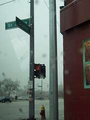
St. Aubin and Gratiot
i've started to field test my mapping/photography project even though it isn't completely functional [ by that i mean there's some manual set up required on my part and on the part of you, the viewer ]...
briefly, this is what i've done... i've taken the stompbox out on the road with a gps attached to it... i connected to that box with my laptop [ mac powerbook 12" osx 10.4.4 ] wirelessly... i ran two scripts [ both perl, both running on my laptop ] to log gps points... one logged the points automatically each second to a file locally [ on my laptop ] and the other logged points remotely [ to a file on my web server ] each time i ran the script. this dual logging is a result of not being able to get either one to do both things i wanted simultaneously... nor was i able to get either to run on the stompbox itself. ideally, the script would run on the stompbox [ therefore not requiring my presense or a second computer. it would log location [ as well as time, altitude, velocity ] at even increments to a remote XML file on my web server... at any rate this is what i've got working so far...
so... here's what you have to do... view these images using firefox 1.5 or higher, install the greasemonkey extension [ you'll have to restart firefox ] and load the GMiF script [ right click on the link on that page and select install user script ] and then when you view this image in flickr you will get a new button above the image at the right side that says Gmap... click that and the images will load on a map right in flickr [ thus, GMiF or Google Maps in Flickr ].
some of the other steps i needed to work out to make this work were to add the longitude and latitude data to the photos... for this i used GPSPhotoLinker to write to the EXIF meta data of each photo... this is okay for the above solution because GMiF reads EXIF data, but other flickr/gmap hacks do not... they read IPTC meta data which is also converted into tags in flickr, so there may be a more elegant solution to this that doesn't require the viewer to install anything... i'll be looking into this.
i'm also not convinced that all the locations are in the correct places, but i have some solutions in the works for refining that information as well... in the meantime, this is as good as it gets... enjoy.
This entry was posted
on Wednesday, February 22, 2006 at 12:23:00 AM.
You can skip to the end and leave a response.
![]()
![]()
Wednesday, February 22, 2006 1:51:00 PMyeah! it's working...except there are two pictures....hmmm...*sniffle*cough*
Thursday, February 23, 2006 1:11:00 AM
ahhh... finally! that was the most painful post ever...
» Post a Comment